In 2019-2020, a collaborative project was undertaken between Colchester Borough Council, BA Photography students from UCC Colchester Institute, Colchester Archaeological Trust and archaeological imaging consultant Prof. Dominic Powlesland, to generate an accurate 3D model of the Balkerne Gate.
The gate was recorded in detail with an overlapping grid of high-resolution digital photographs. The images were used to create a very accurate 3D surface model, and one that can be accessed from a multitude of vantage points and viewing distances. The principle method uses well-established computing algorithms, using Structure from Motion (SfM) to reconstruct 3D space from the multiple overlapping images. The results are shared using Sketchfab, which is dedicated to the publication and sharing of digital 3D models.
The 3D model is important for conservation recording and management of the Town Wall, serving as an accurate point-in-time record of the gate that can be revisited in the future to study alteration, erosion and damage.
More detailed information about the digital recording technique can be found in the Historic England good practice guidance Photogrammetric Applications for Cultural Heritage.
The results of the project are available here.
The Balkerne Gate was the main (west) gate into the walled Roman town and one of six gates around the circuit of the Town Wall. The Gate incorporated an existing free-standing monumental arch (with two archways) built to celebrate the Claudian conquest of Britain, probably in the AD 50s, and faced with tufa stone brought from the Hampshire coast. This created a double-arched gateway with flanking walkway arches and external guardrooms, 30m wide N to S, as shown in the reconstruction drawing below by Peter Gray. The archways formed the main carriageways with the addition of a footway and a bastion on both sides to form the Balkerne Gate.
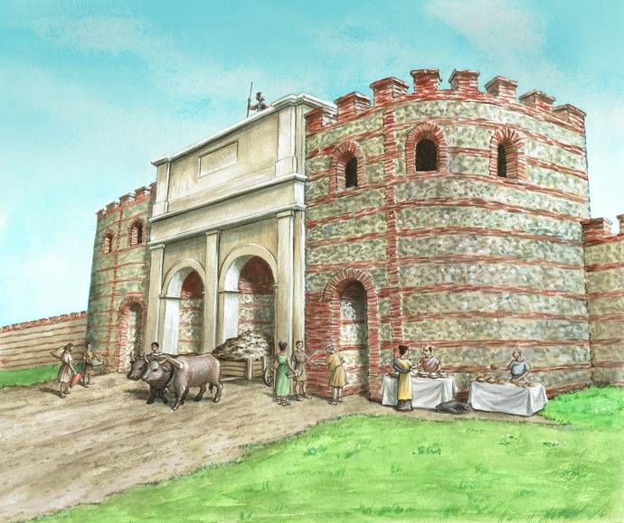
In the late 3rd century, the Balkerne Gate was closed and the external defensive ditch was extended to close off the road (i.e. the ditch was dug across the carriageways). The monumental arch and part of the rest of the gate was demolished and the rubble used to block the gap; the south pedestrian walkway, however, seems to have been left open. The south-west gate, or Head Gate became the main gate into the town after the Balkerne Gate was blocked in the late 3rd century, and it was the principal gate into the later medieval town.
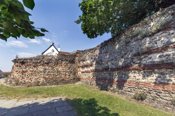
The surviving (southern) pedestrian archway of the Balkerne Gate, still in use today, and southern bastion (and also part of the northern bastion) is only a small part of what was once an impressive entrance into Colchester, in keeping with the importance of the town. The base of the blocked carriageways are visible below the parapet of the Hole in the Wall public house.
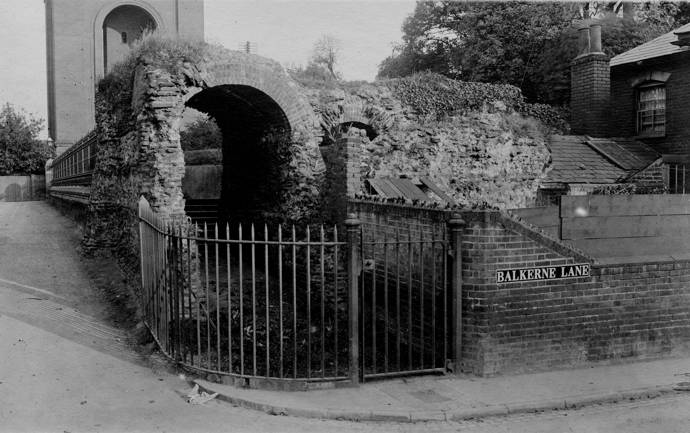
The Balkerne Gate in 1913. Notice the house that is built against the Wall, to the south of the Gate. This, and other buildings along Balkerne Lane, were demolished in advance of the construction of the dual carriageway in 1977.
Colchester’s Town Wall is the earliest and one of the most complete town wall circuits surviving from Roman Britain, dated to c.AD 65-80. The Wall was constructed in a calcareous mudstone, septaria, imported from an outcrop near Harwich, supplemented by courses of brick. Nearly two thirds of the wall circuit still exists with the remainder surviving as buried archaeological remains; originally the Wall formed a circuit 2.8km long and 2.4m thick, and enclosed a rectangular area of 48ha. Six gates were built in the Wall and internal rectangular towers were constructed on the inside of the Wall; today, there are the upstanding remains of only two gates, the Balkerne Gate and Duncan’s Gate.
A large defensive ditch, over 5m wide and 3m deep, was dug around the outer foot of the Wall, around the same time as the construction of the Wall. This ditch was subsequently recut and enlarged in c.AD 275. An interior rampart was also added to the Wall in the mid-2nd century AD.
The Wall was repaired and refurbished in AD 917 by Edward the Elder. A substantial ditch was cut along the south side of the Wall in the late 10th or 11th century, 7.5m wide and 3.0m deep. An extensive programme of repairs was carried out in the 14th century and eight bastions were added along the south-east circuit. One of the best preserved bastions, Bastion 5, is today situated in Priory Street car park. The Civil War was the last military action seen by the Town Wall.
Unlike many other town walls, subsequent alterations have not altered the essential character of the circuit and it continues to define the historic centre of the town. It is one of the most important historic features and visual reminders of the Roman town, as most of the Roman evidence is buried deep underground.
In 2019, Colchester Borough Council adopted a new management plan. The plan sets out a framework for the maintenance, enhancement, interpretation, presentation and celebration of the Town Wall and its setting.
During the final week of excavations in 2014 at the Williams and Griffin store at High Street, Colchester, archaeologists discovered a hoard of Roman gold and silver jewellery and coins. This is the first hoard of precious metals ever found in Colchester. It is especially significant as it was found in a small pit within the floor of a house and appears to have been buried for safekeeping during the early stages of the Boudican revolt in AD 61. The jewellery was buried under the floor of a house which was subsequently burnt to the ground, along with the rest of the town.
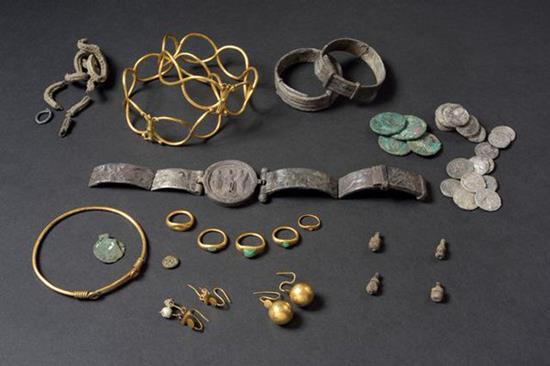 The collection of jewellery included one gold and two silver bracelets, two gold and one silver armlets, five gold finger-rings, a silver chain and loop, a copper-alloy bulla (pendant worn around the neck), a glass intaglio with the incised image of a panther, a collection of Roman republican coins, and the remains of a jewellery box containing two sets of gold earrings and four of the gold finger-rings. The jewellery appears to have belonged to a wealthy Roman woman who lived in Colchester.
The 'Fenwick hoard', as this collection of jewellery is known, is currently on display at Colchester Castle.
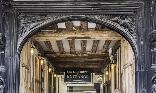 The Red Lion Hotel is one of the earliest surviving and best-preserved buildings in Colchester town centre. The Red Lion was built originally as a town house for John Howard, Lord Howard, later the duke of Norfolk in 1481 or 1482 and the heraldic badge of the Howards is carved on the façade, over the gateway.
Seventeen samples were taken for tree-ring dating in 2016, from different sections of the building. These indicate, perhaps surprisingly, that different sections were built within a very short timescale. Two posts from the front range provided a date of AD 1475/76 or soon after. A post from the southern hall, in the rear of the west range, was dated to AD 1475 and matched the date of a post at the rear of the east range.
By 1515 it had become a public hostelry, originally the New Inn or The White Lion, but is possible that some of the building complex could have remained in Howard occupation. After 1603, it became known as the Red Lion in honour of James VI of Scotland and I of England, whose Scottish royal arms featured a red lion.
The archway is decorated with St George and the Dragon and two male figures which possibly represent merchants or lawyers. As in previous centuries, today the lower part of the building is used for retail, with the hotel on the upper floors.